All our online summer focus resources are over here.
If you grew up in New England or the Upper Midwest you’re used to seeing indigenous people’s place names for the towns, cities, rivers, and lakes around you—but here in Indiana, White settlers did a through job of erasing indigenous place names from the map of the state. It’s strange to look on Indiana’s landscape pretty much anywhere and tell ourselves that it was named, claimed, and loved by others. But the history is here if we look for it. Here are some places to look.

Close to Bloomington, the Ten O’Clock Line was a marker for the Treaty of Fort Wayne (1809), negotiated by William Henry Harrison with the Delaware and other indigenous peoples. The story is that the boundary was marked by the shadow of a spear thrown at 10:00 am. You can walk part of the Ten O’Clock Line in Brown County State Park. The treaty did not hold and was followed by Tecumseh’s War.

You can follow the consequences of the Treaty’s failure by heading north to Prophetstown, Indiana, site of Prophetstown State Park, which has outdoor interpretive displays about Indiana’s indigenous peoples (and apparently a great water slide, by the way). In nearby Battle Ground, site of the Battle of Tippecanoe, the Tippecanoe County Historical Society maintains the Tippecanoe Battlefield and Museum offering a monument, wooded hiking trails, and a gift shop.
Tecumseh and his brother, the Prophet, are important figures not just in Indiana history but in United States history. If you’d like to find out more about them, the Monroe County Public Library has a couple dozen books on Tecumseh ranging from easy-readers to doorstop-sized historical biographies. Alexander Thom’s Panther in the Sky is a fictionalized version of Tecumseh’s life.
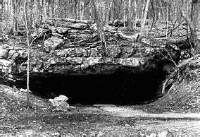
Turning southward from Bloomington, we move into territory of interest to archaeologists and archaeology-obsessed kids. The Wyandotte Caves in O’Bannon State Park may or may not be open, so call first? Wikipedia says, “Wyandotte Cave was used by Native Americans for nearly 4000 years before Europeans arrived in the area; carbon dating of artifacts provided evidence of human activity potentially as far back as 8000 BC. The Native Americans used torches made of hickory bark and grape vines to light the cave where they mined for aragonite, which they used for pipes and necklaces, and chert, which they used to make stone tools. The remains of their mining explorations can be seen on tours to this day.” Tours for the intrepid can run up to two hours, including a crawling tour. The mind reels.

On the banks of the Ohio River near Evansville you can visit Angel Mounds State Historic Site. The Interpretive Center is closed this summer but here are hiking trails and outdoor exhibits of both indigenous life and the history of archaeological exploration at the site. While you’re in the area, Falls of the Ohio State Park near Clarksville, with its huge bed of exposed Devonian limestone, is beloved to fossil hunters.
What are other places to learn about the history of Indiana’s indigenous peoples? Comments are open — suggestions welcome!
You must be logged in to post a comment.